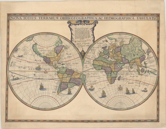
A new addition to the State Library collection, the Hondius World Map by Jodocus Hondius the younger (1594/1595 – 1629) is the earliest printed map to show the recent Dutch explorations on the West Coast of Australia.
This exceptional map was first issued by Jodocus Hondius the younger around 1625, and Clement de Jonghe engraved this third state edition in 1664. Jodocus Hondius the younger derived his geographical knowledge of Australia from the unpublished 1622 map of the Indian Ocean by Hessel Gerritz. First issued around 1625 and engraved by Francis van der Hoeye.
In 1616, Dirk Hartog, captaining the Dutch East India Company (VOC) ship Eendracht (meaning 'Unity'), accidentally went off course en route from the Netherlands to Indonesia and encountered the west coast of the Australian mainland. He landed close to 26º South, at what is now known as Dirk Hartog Island in the Shark's Bay area of Western Australia.
After departing Dirk Hartog Island, the Eendracht sailed northwards along Western Australia, all the while charting the Australian coastline. In honour of his voyage, he named the land "T Landt van d'Eendracht" (the Land of the Eendracht). By 1619 this name was used in all documents referring to the sub-continent (Australia) until 1644 when it was replaced by "Nieuw Holland". Hartog's cartography remained in manuscript form for some years, in part, because of the VOC's cartographic secrecy laws.
The map appeared in several states:
- Jodocus Hondius (undated, with Hondius' name in the top centre).
- Franciscus Hoeius (dated 1630), who signs the plate below the celestial globe at the bottom centre of the map.
- Clement de Jonghe (dated 1664). - Johannes Van Keulen (1680s: 3 different states).
The Hondius world map was soon followed by Hessel Gerritsz's Caert van't Landt van d'Eendracht (Amsterdam, 1627), a chart that specifically focused on the coasts of Western Australia.
Francis van der Hoeye (aka Franciscus Hoeius, 1590-1636) worked in Amsterdam as a copper plate engraver and publisher from 1629 until his death in 1636 (Schilder, 1979). Van der Hoeye is known to have acquired and re-issued several multi-sheet world maps published originally by Blaeu and Hondius. The map was originally conceived by Jodocus Hondius the younger (1594-1629), whose eponymous father played a large part in the rise of Amsterdam as the dominant cartographic production centre of the 17th Century. Hondius' bother-in-law, Jan Jansson (1588-1664), later transformed the Hondius firm into a powerhouse of geographical publications.
Topic