Skip to main content
Skip to main content
Skip to search
Utility bar
Facebook
Instagram
YouTube
Accessibility
Give
My Library Card Login
Search the Catalogue
Ask a Librarian
Menu
State Library of Western Australia
Search
Login
Main navigation
Research & collections
Catalogue
How to use the catalogue
eResources
Aboriginal collections
Indigenous music
Indigenous oral history
Storylines
Collections
Artwork
Diaries
Ephemera
Film
Maps, plans & charts
Music
Newspapers
Oral histories
Photographs
Picture book illustration
Police gazettes
Post office directories
Private archives
Read WA
Family history
Getting started
Aboriginal family history
Dead Reckoning: WA Family History Guide
Explore by country
J.S. Battye Library
Australian Joint Copying Project (AJCP)
Ships and passengers
Family history eResources
Western Australia
Historical panoramas
Treasures
Plan My Visit
Hours, transport, access
Access and inclusion
Bags, baby room and public toilets
Emergency evacuation procedure
Food and drink
Floor plans by level
Opening hours
Parking and transport
Services
Ask a Librarian
Borrowing
Computers and internet
Digital literacy
Family History WA (FHWA)
Justice of the Peace
Microform and media player equipment
Multicultural Information and Services
Order a copy
Printing, copying and scanning
Spaces to visit
Acknowledgement of Country Artwork
Board at the Library
Community Languages Collection
Discovery Lounge
Ground and Co Cafe
J.S. Battye Library
Leah Jane Cohen Reading Room
State Archives
The Story Place
WACE Study Space
Children & families
Parents
The Story Place
eResources for Families
Venue Hire
Stories
Topics
Aboriginal stories
ANZAC stories
Small towns and regional cities
WA history
SLWA on ABC Radio
Podcasts
What's On
Events
Exhibitions
Awards & fellowships
Grants
Learning
Educators
Online Incursions
Excursions
Classroom resources
Teacher essentials
Community language teachers
Languages
Literacy
Adult Literacy Collection
Better Beginnings
Children's Literacy
Students
eResources for teachers and students
How Do I?
Become a member
How to use the Catalogue
Order a copy
Contribute to State Library collections
Donate to our collections
For photographers and film makers
For publishers and authors
Suggest a purchase
Give
Giving at the State Library
Areas of Support
Make a Donation
Our Supporters
Leave a Bequest
Volunteer
Public Libraries
Find a public library
eresources for public libraries
About Us
Contact us
Ask a Librarian
Feedback
Connect
Social media
Subscribe
YouTube
Corporate information
Annual reports
Censorship
Copyright in Library Collections
Freedom of information
Library Board
Media centre
Organisational structure
Regulations, policies & guidelines
State Librarian and senior staff
Strategies, plans and annual reports
Dialogues 2029
History of the library
News from the library
Partnerships
Local government and Public Libraries
NSLA
Partnership Enquiries
What we do
Collecting and Sharing for the Future
Preservation
Work with us
Search
Search
Enter Your Search
Submit Your Search
Search type
website
catalogue
Breadcrumb
Home
b1805940_1_map of Perth Map of Perth with original lakes and swamplands 1838
Image
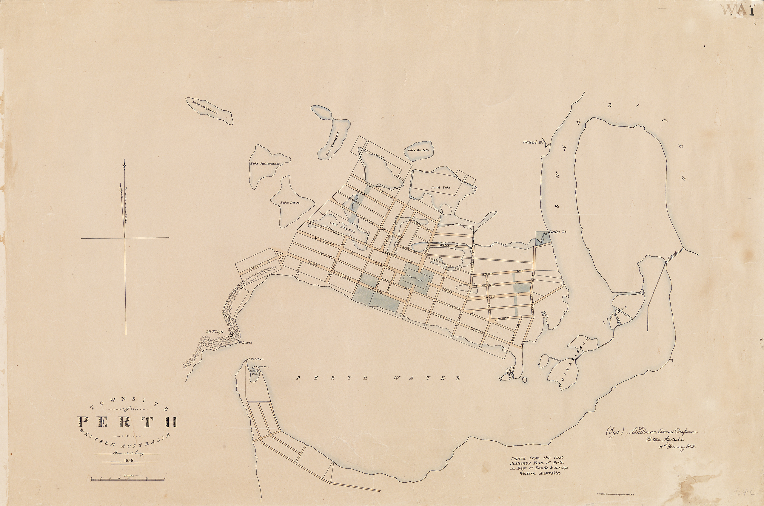
Map of Perth with original lakes and swamplands shown, 1838
View item in catalogue
Alfred Hillman [cartographic material] from actual survey 1838; Published/Produced: Perth WA Dept of Lands & Surveys