
A new addition to the State Library collection is the scientifically important map, Noua orbis terrarum delineatio singulari ratione accommodata meridiano tabb, rudolphi astronomicarum, 1630 (1658). In English, "A Modern Depiction of the World, for the Sole Reason of Bringing the Depiction into Line with the Equator According to the Rudolphine Astronomical Tables".
Designed and engraved by the Nuremberg cartographer Philip Eckebrecht at the request of his friend Johannes Kepler. The map was intended to illustrate his Rudolphine Tables, used to more precisely calculate the positions of the moon and the known planets.
In memory of Rudolf II, Holy Roman Emperor, the tables were named "Rudolphine". The Holy Roman Emperor sponsored Keplers research and was represented on the map by the German Imperial double-headed eagle, holding all the world in its wings, an allegory of imperial protection.
The map was completed after the first edition of the tables in 1627 but later included in the 1658 updated edition, with a dedication to Emperor Leopold, crowned in the same year.
Information in the tables and the map allowed calculation of longitude based on observation, compared to previous calculations requiring maintenance of cumbersome accurate clocks. This method was a significant step forward in navigation across the oceans and recording explorations. The table instructions are written in Latin and found on the left-hand corner of the map in the scroll.

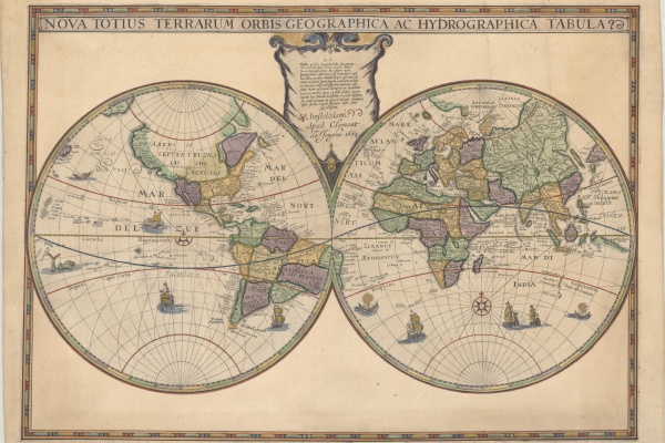
For this purpose, Kepler needed his map to be as up-to-date as possible. Eckebrecht sourced current information, including the World map, Nova Totius Terrarum Orbis Geographica ac Hydrographica Tabula, recently published by Jodocus Hondius the younger in 1625. The Hondious Map included the accidental Dutch exploration of the West Australian coast, shown near the scroll in the bottom right corner.

In 2014, Peter Meurer published an article about discovering a proof state of the Eckebrecht map, bound in a 1630 issue of Kepler's Tables, in the University Library in Kiel (Germany), Cartographica Helvetica, Vol.49 (2014), p.27-38. This confirmed, as suspected from Kepler's letters, there was an unfinished proof state in 1630. The proof state has two hemispheres, but the eagles and outer decorations are only sketched. There is no dedication to Emperor Leopold I. This proof state has many differences between North America and The Great Lakes. New Netherlands is not yet there, and California is not yet an island. The map has the West Australian coastline, making it a cornerstone map for Australia. The coast of West Australia is a one-on-one copy from the 1622-1624 Hondius World Map (first map to show any Dutch explorations in Australia), recently acquired for the State Library's Heritage collection.
On the catalogue, zoom in and see the fine detail including the little squiggle depicting the WA coastline, Latin names, and drawings.
You may also be interested in...
Maps and charts
WA history
A new addition to the State Library collection, the Hondius World Map by Jodocus Hondius the younger (1594 – 1629) is the earliest printed map to show the recent Dutch explorations on the West Coast of Australia.
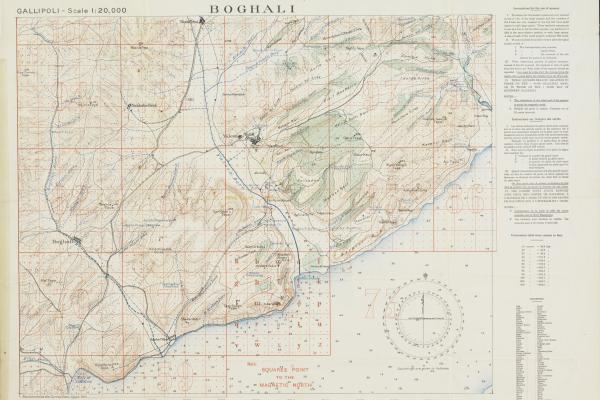
Gallipoli 1915 & Ypres 1917
ANZAC stories
Maps and charts
WA history
In 1915 and 1917, our historical maps of Gallipoli and Ypres were working documents. Paying attention to them could be the difference between a soldier writing home or someone else writing to their family.
The State Library aims to collect a copy of every map and chart produced in Western Australia and is a legal deposit library for all Government and private publishers.
Topic